
HurricaneMapping's Shapefile Dataset Description - Technical Note
- Introduction
- File Formats
- What is a Shapefile?
- HurricaneMapping Shapefiles
- Layer Files
- HurricaneMapping Distribution Format
- Advisory Issuance Times
- Storm Advisory Map Data
- Current Location and Wind Ranges
- Forecast Track
- Forecast Wind Swath
- Forecast Error Swath
- Wind Probabilities
- Past Track
- Advisory Positions
- Past Wind Swath
- Watches and Warnings
- Rainfall Isopleths
- Flooding Outlook
- Base Map Data
- Technical Support
- Legal Notices
Introduction
This manual describes file formats and data types contained within HurricaneMapping.com’s shapefile datasets. These datasets are designed for storm tracking and threat analysis purposes within ESRI’s ArcGIS software. They are derived primarily from National Hurricane Center, Central Pacific Hurricane Center, and Joint Typhoon Warning Center forecast advisories issued for tropical depressions, tropical storms, and hurricanes or typhoons.
HurricaneMapping servers ingest these official government forecasts, then model and convert the data to sets of map layers. Datasets may be downloaded from http://www.hurricanemapping.com/data using a web browser or retrieved from HurricaneMapping’s servers using a desktop utility called Shapefile Manager that is provided free-of-charge to HurricaneMapping Shapefile subscribers.
File Formats
What is a Shapefile?
Shapefile is a widely adopted vector data format for describing geospatial points, lines, and polygons along with their associated tabular attribute data. ESRI developed the format with open specifications, and therefore many Geographic Information System software programs have incorporated the ability to read and write shapefile data.
The shapefile (with an “.shp” extension) stores geometry of either points, lines, or polygons. It must be accompanied by two supporting files of the same name—an ”.shx” file containing an index to the geometry, and a “.dbf” storing a database of attributes associated with the geometric shapes. A number of other files having the same name but different extensions may also accompany the .shp file. Most notable of these are the “.prj” file that stores the geographic coordinate system, or projection, and the “.shp.xml” that stores metadata.
HurricaneMapping Shapefiles
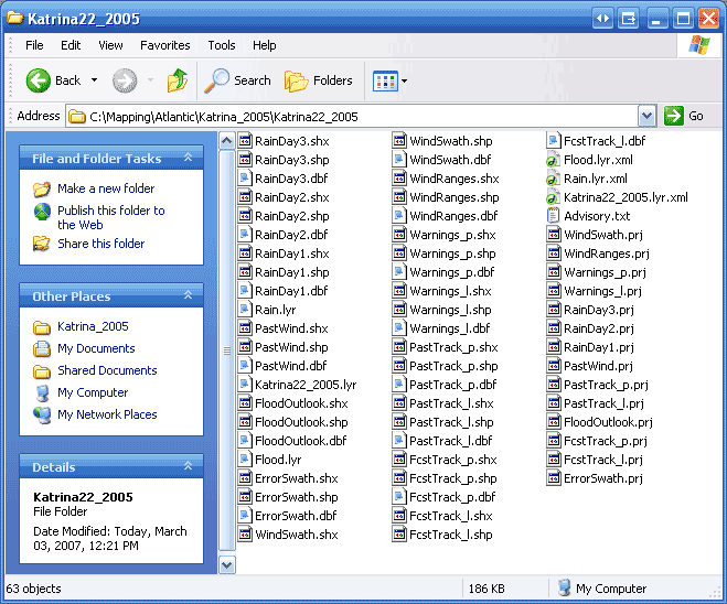
A HurricaneMapping storm advisory dataset consists of a folder collection of ‘shapefiles’--same-named .shp, .shx, .dbf, .prj, and .shp.xml files. These datasets can contain as many as 15 different shapefiles.
Below are the contents of the dataset folder for Advisory #22 of Hurricane Katrina from the year 2005 (named Katrina22_2005).
Layer Files
HurricaneMapping datasets also contain 1 to 3 “.lyr” files. These ‘layer’ files are specifically for use in ESRI’s ArcGIS 8.2 or higher. Their purpose is to describe how a shapefile or group of shapefiles should be symbolized, labeled, and otherwise displayed within ArcMap of the ArcGIS software. Use of these layer files will be illustrated later in this document.
HurricaneMapping Distribution Format
HurricaneMapping shapefile datasets are distributed in the form of a zipped folder of files (i.e. Katrina22_2005.zip contains the folder Katrina22_2005 with all of the files shown previously). Our Shapefile Manager utility will automate the unzipping process or you can use any zip utility of your choice to extract the data.
Advisory Issuance Times
The Hurricane Centers have the following standard times for forecast advisory issuance:
- 09 UTC (5 AM EDT) Where UTC is also known as GMT or Zulu
- 15 UTC (11 AM EDT)
- 21 UTC (5 PM EDT)
- 03 UTC (11 PM EDT)
In actual practice, issuance of the Hurricane Center advisory often is up to 30 minutes earlier. A HurricaneMapping Shapefile dataset is ready for retrieval less than 5 minutes later. Intermediate advisories having a letter extension of A or B (i.e. Katrina22A_2005.zip) are issued at 2 or 3-hour intervals when storms are nearing landfall and either watches or warnings are issued. HurricaneMapping’s servers also publish these advisory datasets as well.
Storm Advisory Map Data
HurricaneMapping’s advisory datasets will contain various map layers depending on the conditions of the storm. Here we have loaded into ArcMap, the three layer files (Katrina22_2005.lyr, Rain.lyr, and Flood.lyr) from the dataset shown earlier.
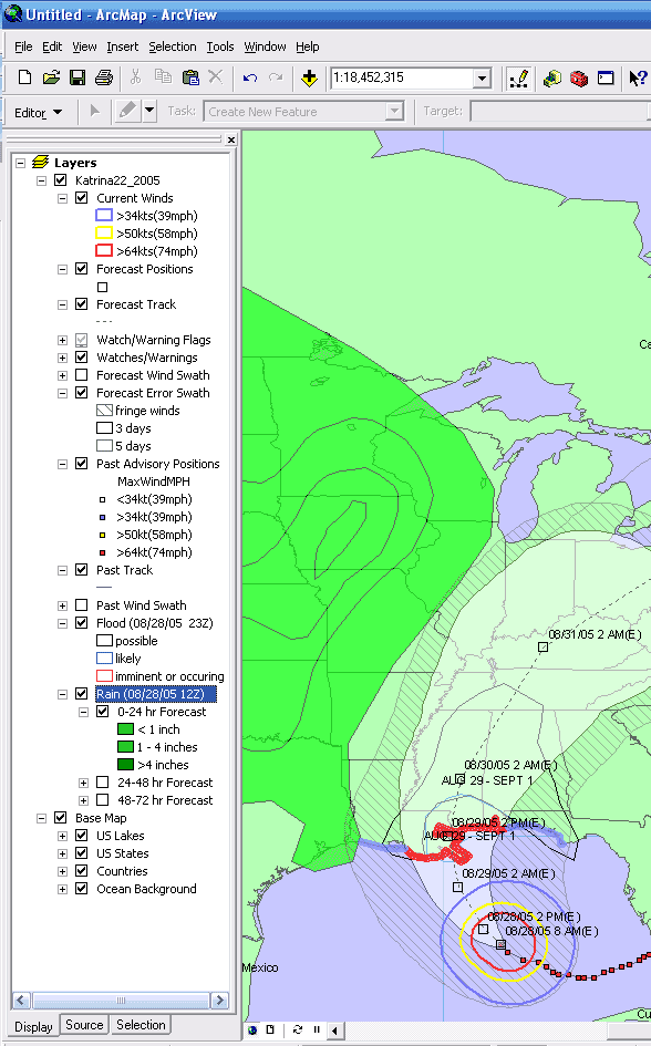
Individual layers are illustrated and discussed below:
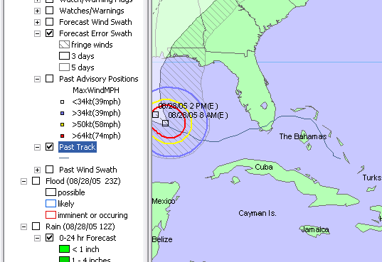
Current Location and Wind Ranges
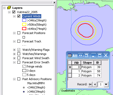
Current winds are derived from WindRanges.shp, a shapefile with up to three polygons.
The rings represent the extent of tropical storm force winds (34kt or 39mph) in blue, 50kt or 58mph winds in yellow, and hurricane force (64kt or 74mph) winds in red. These are the 3 standard wind ranges provided by the Hurricane Centers.
Forecast Track
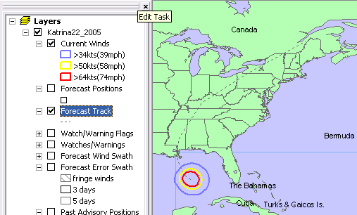
Forecast Track is the dashed line ahead of the storm representing where the storm center is projected to track within the next 3 to 5 days (72 to 120 hours). It is derived from FcstTrack_l.shp.
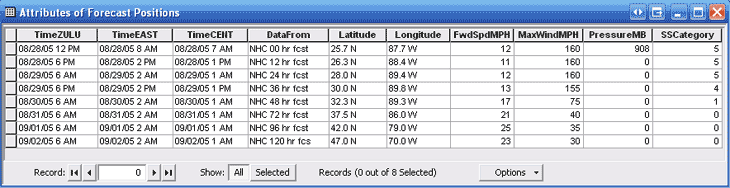
Forecast Positions
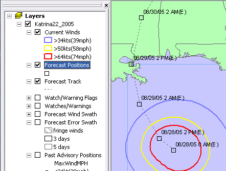
Forecast Positions are derived from a point shapefile-- FcstTrack_p.shp.
The Hurricane Center issues storm location and intensity projections for up to seven time periods--12, 24, 36, 48, 72, 96, and 120 hours into the future. These are shown in ArcMap as open squares along the forecasted track. They are labeled by default with the date and Eastern Time.
A number of attribute fields are provided with FcstTrack_p.shp for labeling and analysis purposes. Note that Central and Zulu time are also included here.
Forecast Wind Swath
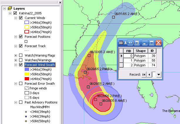
Forecast Wind Swath is derived from a polygon shapefile called WindSwath.shp.
It represents a composite of wind ranges throughout a 72-hour forecast period.
The fill colors represent the extent of tropical storm force winds (34kt or 39mph) in blue, 50kt or 58mph winds in yellow, and hurricane force (64kt or 74mph) winds in red.
Forecast Error Swath
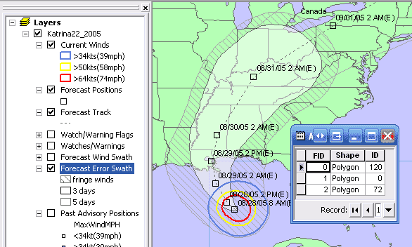
Forecast Error Swath is derived from ErrorSwath.shp.
The large white swath in the middle represents the area in which the storm center is most likely track within the next 72 hours(3 days). The swath gets wider at a rate equal to the average error rate per hour of forecast, and thus is quite wide in the latter hours. This reflects the uncertainty in the hurricane forecast process...specifically the 10-year average forecast track error. The swath means that even though the Hurricane Center has forecast a specific track, the storm could end up anywhere within the swath within the next 72 hours, with around a 60% confidence level.
Tropical storm force winds (Fringe Winds, polygon attribute=0) might occur in the hatched area if the storm tracked at the outer edge of the error swath.
The transparent area bordered by a gray ellipse represents the Average Error Swath for 73 to 120 hours (5 days). (cut off in this illustration)
Wind Probabilities
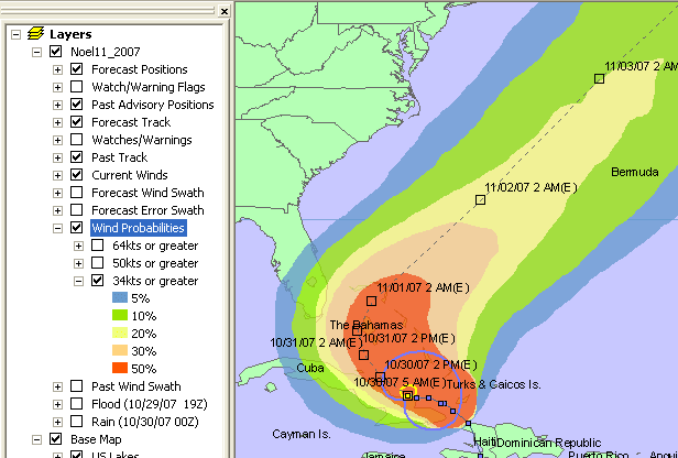
Probabilities for winds of at least 34kt, 50kt, and 64kt are derived from three shapefiles—Probs_34.shp, Probs_50.shp, and Probs_64.shp. Wind probabilities were introduced into the HurricaneMapping datafeed in October 2007 and appear only for storms of the Atlantic and Northern Pacific basins.
HurricaneMapping's wind probability shapefiles contain polygons representing 5 ranges: probabilities of at least 5%, 10%, 20%, 30%, and 50%. These polygons are the result of boundary analysis performed on the TPC/NHC's gridded wind probability products.
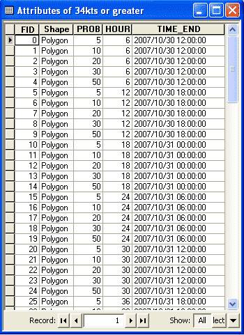
The large 120-hour cumulative probability (shown above) appears last in the shapefile and thus obscures shorter-term cumulative periods (0-6 hour, 0-12 hour, 0-18 hour, etc.). In ArcMap, a Definition Query such as ‘HOUR=72’ can be used to uncover the wind probabilities for a shorter time period.
Additional information available at: https://hurricanemapping.com/2007season/windprobs.cfm
Past Track
Past Track (PastTrack_l.shp) is the solid line representing the actual path the storm has taken.
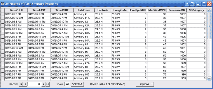
Advisory Positions
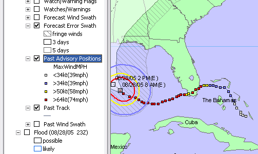
Advisory Positions are derived from a point shapefile-- PastTrack_p.shp.
These points are the observed locations of the storm center at the time of previous advisory issuances. They are colored according to the maximum intensity of winds at those times.
A number of attribute fields are provided for labeling and analysis purposes
Past Wind Swath
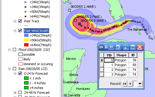
This wind swath is derived from PastWind.shp and represents a composite of observed wind ranges from past advisories.
The fill colors represent the extent of tropical storm force winds (34kt or 39mph) in blue, 50kt or 58mph winds in yellow, and hurricane force (64kt or 74mph) winds in red.
Watches and Warnings
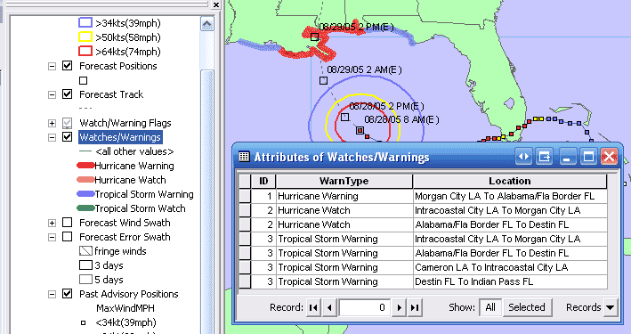
Watches and warnings are derived from two shapefiles—Warnings_l.shp and Warnings_p.shp. They appear as lines along the coast and as points marking the starting and ending location for each item.
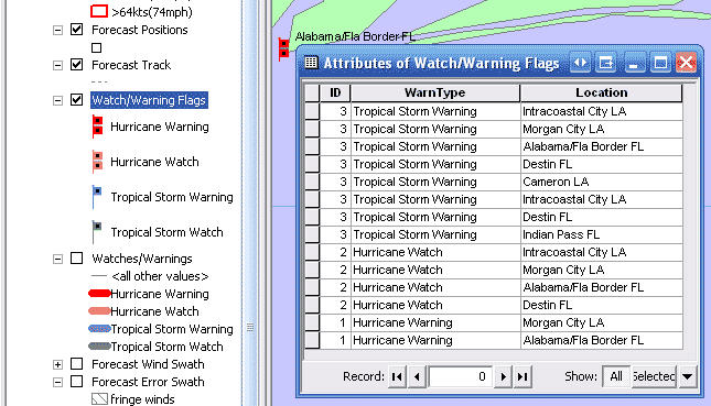
Hurricane warnings(red) are issued when hurricane conditions are expected within 24 hours and hurricane watches(pink) are issued when hurricane conditions are possible within 36 hours. Tropical storm warnings(blue) are issued where those conditions are expected within 24 hours and tropical storm watches(green) are issued when that threat is possible within 36 hours.
Rainfall Isopleths
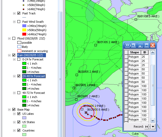
This rainfall layer is derived from three polygon shapefiles—RainDay1.shp, RainDay2.shp, and RainDay3.shp. The HPC (NOAA Hydro-Met Prediction Center) issues 24-hour rainfall forecasts for Day 1, Day 2, and Day 3. The polygons are isopleths of rainfall amount, meaning that higher amounts of rain are nested within the lower amounts. The attribute table lists each isopleth’s rain total in hundredths of an inch.
Flooding Outlook
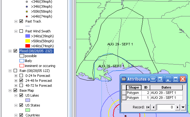
The flood outlook is derived from a polygon shapefile called FloodOutlook.shp.
The HPC issues a 5-day forecast of freshwater flooding hazards for the continental US, using more specific forecasts for each flood basin provided by several regional NWS River Forecast Centers around the country.
The forecast takes the form of polygon regions that are outlined in colors according to the likelihood of flooding. The categories are defined as follows:
- Occurring/Imminent (red) - Significant flooding is already occurring or is forecast to occur during the outlook period.
- Likely (blue) – Significant flooding can be expected during the outlook period.
- Possible (black) - Significant flooding could occur. Such flooding in neither certain nor imminent.
Polygons are attributed with the dates within the 5-day period in which the flooding is expected.
Base Map Data
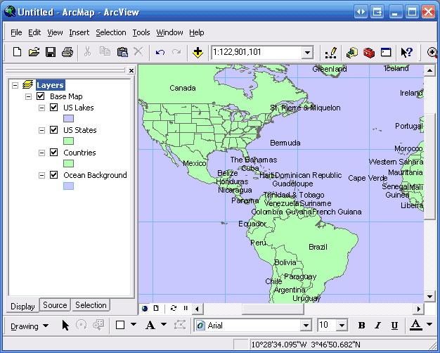
This collection of shapefiles, along with a .lyr file, is made available for you to use as a storm tracking base map if desired. The zipped folder can be downloaded from http://www.hurricanemapping.com/data/BaseMap.zip.
Note: Users of HurricaneMapping’s Shapefile Manager will already have this on their computers.
Technical Support
Help for this and all other HurricaneMapping products and services is available 24/7 at support@hurricanemapping.com or (888)840-4089.
Documentation/Help for HurricaneMapping's Shapefile Manager is available from within the program or online at http://www.hurricanemapping.com/support/shapefilemanager
Instructions for downloading Shapefile Manager are sent to each registrant after the registration process is completed.
Legal Notices
©2007 Sea Island Software, Incorporated. All rights reserved.
HurricaneMapping Shapefile Dataset Description, Ver. 1.0
This document, as well as the software described in it, is furnished under subscription and may be used or copied only in accordance with the terms of the HurricaneMapping subscription agreement. The contents of this document are subject to change without notice and do not represent a commitment on the part of the Sea Island Software, Inc.
ArcGIS™ and ArcMap™ are trademarks of ESRI Inc.
Products named herein may be trademarks of their respective manufacturers and are hereby recognized. Trademarked names are used editorially, to the benefit of the trademark owner, with no intent to infringe on the trademark.