
Wind Probabilities--An Important New Threat Assessment Tool
Part 2 of 3 - Derivations and Formats for Wind Probability Products
TPC/NHC probabilities products for 34kt, 50kt, and 64kt tropical cyclone wind speeds are derived from the Monte Carlo method of randomly sampling alternative tracks and intensities from a large set of plausible forecasts that fall within the average error swath of the official forecast track. A climatology and persistence model (CLIPER) is used to forecast wind extents (size of the three wind radii) for each alternate track.
The TPC/NHC computes wind probabilities for storms that occur in the Atlantic basin, the Eastern Pacific basin, the Central Pacific basin, and the Western Pacific basin. These products are released in graphical form (Figure 6 below) and as raw gridded data in NDFD format (figure 7 below). Additionally, a text version lists wind probabilities for selected cities, similar to the old strike probabilities product that it replaced. Wind probability product release follows the same 6-hour cycle as tropical cyclone advisories, however the NDFD version is typically not available until shortly after the 5am, 11am, 5pm, and 11pm Eastern time advisory issuance hours.
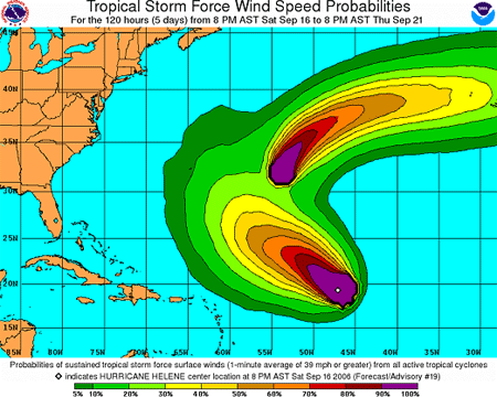
Figure 6. Example of the NHC's graphical product for tropical storm force
wind probabilities
from 2006 storms Helene and Gordon.
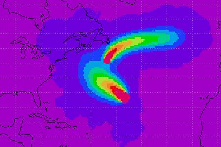
Figure 7. Example of the gridded half-degree NDFD product for tropical storm force
wind probabilities
from 2006 storms Helene and Gordon.
Thus far in this article, we have only been considering wind probabilities for the full 120-hour (5-day) time period. It's important to note that for timing purposes, the NDFD gridded wind probabilities are also available in a host of shorter-term cumulative periods (0-6 hour, 0-12 hour, 0-18 hour, etc...) as well as interval periods (0-6 hour, 6-12 hour, 12-18 hour, etc...). When you consider that these periodic products are produced for all three wind categories (34kt, 50kt, and 64kt), the number of files and amount of data available for each advisory can seem unwieldy. In the final part of this article, we'll take a look at how HurricaneMapping.com condenses all of this wind probability information into a highly useable dataset.
Part 3 - Applying Cumulative Wind Speed Probabilities from HurricaneMapping >>>